The National Hurricane Center (NHC), is eyeing the possibility of some sort of tropical development possibly by the upcoming weekend.
WHERE MAY A SYSTEM DEVELOP?
NHC suggests that over the next 7 days, low pressure may develop inside the yellow area. They are giving this possibility, a low 20% probability of actually forming.
WHY?
 |
This is a forecast map valid on Saturday July 5th. It shows a front moving into north Florida and stalling.
When this happens, it usually has an area of low pressure developing in the Gulf Waters.
If that does take place, then there may be a chance for some growth of the low.
SOUTH FLORIDA IMPACTS?
Uncertainty in the long term forecast stems from the possibility of a disturbance developing sometime later this week. Some of the deterministic guidance hints at an area of low pressure potentially forming somewhere along the stalled frontal boundary (could be over the Gulf waters, or over the Panhandle, or even over the Gulf Stream waters).
However, the lack of model consensus or a consistent trend continues to complicate the forecast. If a system does develop, it could potentially help enhance the aforementioned chances for showers and thunderstorms across the region, and elevate the potential for severe and flooding impacts.
This scenario will need to be monitored closely in the coming days. COURTESY NWSMiami
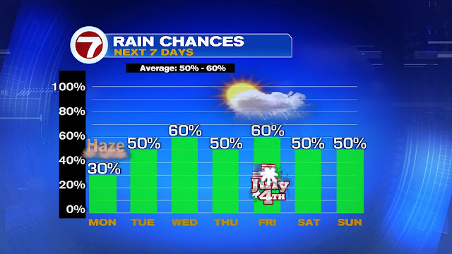
RAIN CHANCES
Over the next 7 days, typical rain probabilities for South Florida range between 50% & 60%. Models suggest this is where we will be thru Friday. Long range into next weekend, keeps the chances on the low end of normal.
We will have to monitor that as it may change depending on where the low actually develops, if at all.
NO tropical concerns for SE Florida, the Bahamas & Cuba at this moment. The worry meter is low.
If there is a change in the models, the entire 7Weather staff will keep you updated. This is a good reminder that we are hurricane season and we should be prepared in case Mother Nature spins anything our way.


