A record setting hurricane is churning in the Central Atlantic aiming for the Windward Islands and beyond. It has intensified very quickly.
Beryl is now a Powerful category 4 hurricane. Extremely strong winds, life-threatening storm surge, and damaging waves are forecast.
- When Beryl passes over portions of the Windward Islands, the highest risk of a core impact will be in St. Vincent and the Grenadines, and Grenada beginning early Monday morning.
- Heavy rainfall and localized flooding are expected across the Windward Islands thru Monday.
As of Sunday morning, it has now reached major hurricane status. Quick History update per CSU's Philip Klotzback.
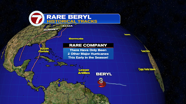
Early morning- Beryl reaches Category 3 hurricane with max winds of 115 mph - the first June major hurricane east of the Lesser Antilles on record. 3rd earliest Atlantic major hurricane on record, trailing Alma (6/8/1966) and Audrey (6/27/1957).
Mid Morning- Beryl attains winds of 120 mph - the second strongest June hurricane on record.
- Beryl trails only Hurricane Audrey (1957, 125 mph max winds).
Early Afternoon- Beryl reaches category 4 intensity with 140 mph winds!
- This is the earliest calendar year Atlantic Category 4 hurricane on record. Old Atlantic record for earliest Category 4 hurricane was Hurricane Dennis on July 8, 2005
Recon Mission
At 11:35 Sunday morning -NOAA and Air Force Reserve hurricane hunter aircraft data indicated that Beryl had strengthened to an extremely dangerous category 4 hurricane. The maximum sustained winds are estimated to be 130 mph (215 km/h) with stronger gusts.
Forecast Cone
The NHC track forecast has been nudged to the south of the previous run.
- Beryl is expected to be a very dangerous category 4 hurricane when it moves through Windward Islands.
- Strong Upper winds (Shear) should gradually increase when Beryl moves across the Caribbean Sea. It may weaken thereafter BUT it is expected to remain a significant hurricane through the next 5 days.
Where to find the strongest winds
This forecast suggests the core of Beryl tracking across the Windward Islands Monday morning and then traveling over the
Caribbean Sea during the following days. The purple swath is where those winds, 75 mph to Cat 3, (possibly 4 by then) will be registered.
Areas along the Windward Islands may get up to a foot of rain, while in the Caribbean Sea, the downpours will taper off to 4 to 8 inches.
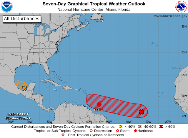
Two More Areas to Watch
Aside from Beryl, there is another area marked by the red "X", which has a 70% chance for developing over the exact same area Beryl currently resides.
Then in the Bay of Campeche in the Gulf of Mexico, a low has a 50% chance for growth. Even without development, it's forecast to drop plenty of rain there.
We'll be watching


No comments:
Post a Comment