Three Tropical Areas to watch as we head into the weekend. We could see the second named storm of the year and the first Tropical Threat for the caribbean.
What to Watch
1) Close to the Yucatan Peninsula, the National Hurricane Center (NHC), is monitoring Invest 94 L. Invest stands for an area NHC would like to INVEST-igate further, 94 is a tracking number and "L", stands for Atlantic Basin. 30% chance for development.
- This feature continues to generate showers and thunderstorms as it moves WNW at 15 mph.
- Recon flight for today is scrubbed.
- It should travel over land and into SW Gulf of Mexico for the first part of the weekend.
2) Invest 95L - Low pressure roughly 1400 miles ESE of the
Windward Islands is looking better defined. Chances up to 100% for formation.
- Showers and thunderstorms are showing signs of organization
- A depression or tropical storm could form as early as Friday afternoon.
- It's moving W at 15 to 20 mph.
- Land approach should be late weekend / early part of next week somewhere along the Lesser Antilles, more likely the Windward Islands.
- Slow development is possible next week as it moves W at 15 to 20 mph.
Invest 94L
Satellite Loop
Even though chances for development are low at 30% over 7 days, it'll drop plenty of rain over parts of Central America, Cayman Islands, Cuba, & Yucatan. It may get a better chance for organization by Sunday in the SW Gulf of Mexico.
Invest 95L
Satellite Loop
The first Tropical Threat for the Caribbean. The Lesser Antilles should monitor closely as it could become an organized named system later on Friday or early Saturday.
Wave Action
While the center of the system is forecast to track into the Windward Islands, wave action will be felt as far north as the Leeward Islands by Sunday. As much as 8 foot seas there. Twelve feet along the center path.
Models
Keep in mind that until the system actually organizes, these forecast tracks are a good estimate and not set in stone. The projections are in agreement in the short term to cross over the Lesser Antilles and move into the Caribbean Sea. After that, they fan out which is typical of long range forecasts and also a sign there are too many variables and the models are not handling it well. Better outcomes once we have a good center fix.
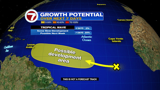
Third in Line
Satellite Loop
This wave is the cluster of clouds and rain just off the West Coast of Africa. Should track south of Cape Verde.
Typically we don't see this much activity early in a season, but with plenty of climatic indicators suggesting an active year, we should all be reviewing our storm supplies and readiness.
We'll keep watching
** Some images courtesy of Tropical Tidbits **


No comments:
Post a Comment