Sunday, June 18, 2023

Depression this week?

The National Hurricane Center (NHC) is monitoring a vigorous tropical wave that could become a depression or even a Storm sometime this coming week. If it becomes a storm it will be named "Bret".

Satellite Imagery


Notice the blob coming off Africa,  that is NOT the wave NHC is focused on. It is the swirl just to its left that has its attention. It is becoming better organized and atmospheric conditions appear favorable for further growth. It may turn into a full fledged tropical system soon.

Invest 92L
Here's the Sunday morning data:
  • Location: Several hundred miles SW of Cape Verde Islands
  • Lat/Lon: 9.7°N 31.9°W
  • Maximum Winds: 28 mph  Gusts: None
  • Minimum Central Pressure: 1010 mb. or 29.82"
  • Movement: West 15 - 20 mph


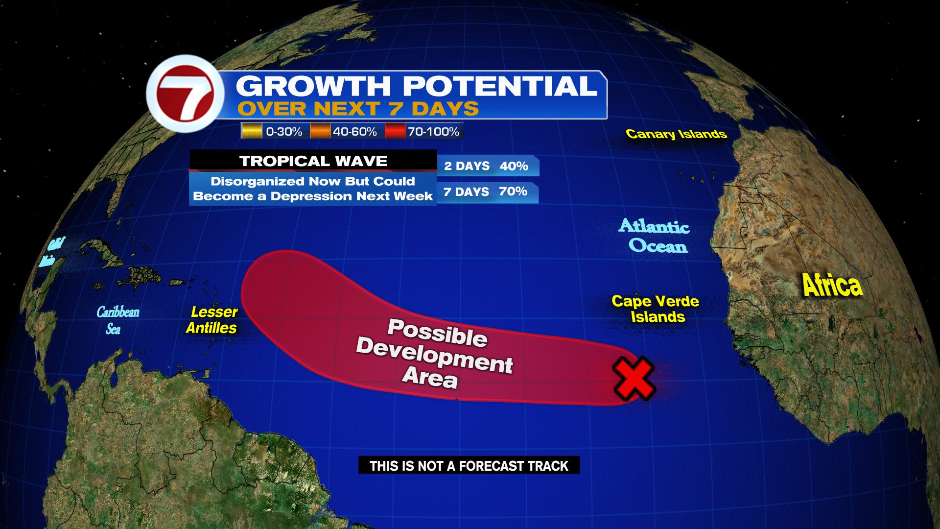
It has a high chance of becoming a tropical system both in the short and long term per NHC. If it does organize, it will do so in the red area.

Models
There is plenty to look at this morning. A reminder as always, that until an actual center of circulation forms, the models are giving us their best tracks possible but not set in stone. Many things can influence a system.

HWRF Model

This particular model shows where the center of the system may be next week. Each line shows a different outcome. The upper right box suggests the system could be a strong one. The bottom right, indicates how low the pressure my be. The lower... the stronger.

HMON Model


This run suggests the center may be East of the Leeward Islands in about 5-7 days and possibly just as strong as indicated by the HWRF.

SPAGHETTI Models:


This takes most of the top models into consideration. The runs are split between an early turn to the north before the islands, or a straight path that may impact the Lesser Antilles and then travel into the Caribbean Sea. I suggest our neighbors to the South keep an eye on this system. 

EURO Model


It forecasts the system to be East of the Lesser Antilles by June 22nd. Notice the small green dot to the right of the islands...that would be the storm. 

GFS: American Model


It turns the system northward avoiding the islands completely. It also forecasts a stronger storm than the EURO.

Bottom Line
Worry Meter for the islands should be Low, BUT keep an eye on the system just in case it does not turn north. Check back every day for the latest to get you ready just in case. The meter may change.

Caribbean: Very Low as of this moment. Things may change if the storm does not shift north.

Florida & Bahamas: No worry now. Check back in case things change.

We'll be watching. 


Saturday, June 17, 2023

INVEST 92L in Atlantic

The National Hurricane Center (NHC), has determined that the wave in the Far Eastern Atlantic, with a high chance for development, is now Invest 92L.  

Satellite Views

The wider image shows how far away the area is from South Florida. It is off the West Coast of Africa a mere 3,785 miles away. It would take roughly 2 weeks for this system to near the U.S. if it were to develop. 


The more close-up view shows a swirl taking place near the Cape Verde Islands. It doesn't have lots of thunderstorm activity but its full of disorganized showers.  It's moving west at a quick speed of around 15-20 mph.  

Typically we don't look at this area for development until late July or August but the waters in the Eastern Atlantic are very warm and it is this heat that can fuel tropical systems.

INVEST 92L
This is a term used by NHC to follow areas that may organize.  Invest stands for an area they would like to INVEST-igate further, 92 is a tracking number (the next one will be 93), and "L" stands for the Atlantic Basin.

Here's the morning data on the Invest:
  • Location: Lon: 10.0°N Lat: 26.6°W
  • Maximum Winds: 23 mph Gusts: N/A
  • Minimum Central Pressure: 1012 mb or 29.88"
Chances for Development


Presently the wave is being impacted by strong upper level winds known as shear and that should help keep it weak. By next week that shear should relax and may allow for some growth. It could become a depression or a storm. NHC is giving it a 70% chance for development in the red shaded area over a period of 7 days.

Surface Map

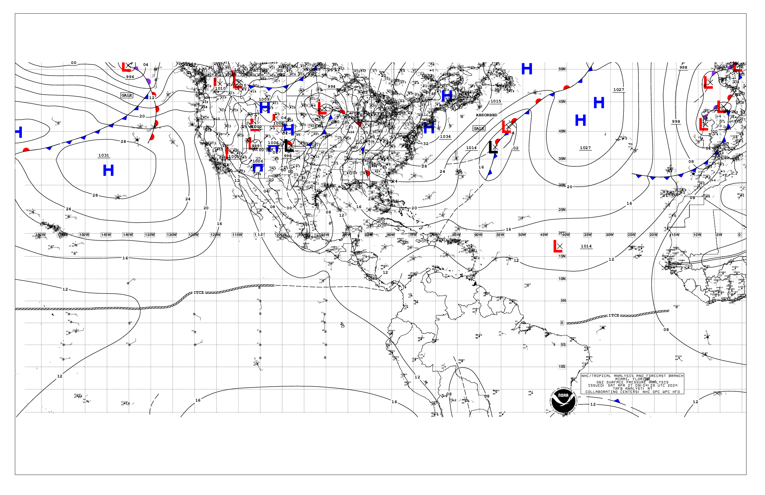
The wave is being steered West by high pressure in the Atlantic. There is also another high next to the U.S. Southeast Coast. The system if it develops, will try to move into the weakness between the two high pressure systems.

Models
A reminder: Since nothings has organized, models are giving us a good but yet educated guess as to where the system may travel.

Spaghetti Models


Reflect where the center of the system may be. Impacts can extend far and wide away from the center.

The European Model

Courtesy Tropical TidBits

This run places what may be a depression or a weak storm East of the Lesser Antilles by Wednesday June 21st.

GFS Model

Courtesy Tropical TidBits

The American Model shows a stronger system north of the Islands by Sunday June 25th.

This is a great reminder we are in hurricane season and we should all be ready. Check out our "Weather or Not" latest podcast issue. It is your personal guide on preparedness that you can listen to at anytime and review as needed.

Of course your 7Weather team is present 24/7 on any tropical threat.

We'll be watching

Friday, June 16, 2023

Far Eastern Atlantic Tropical Wave

A not too common sight in the Eastern Atlantic as a wave has captured the attention of the National Hurricane Center (NHC). 


The large scale satellite imagery shows a small, yet moisture laden wave, just off the West Coast of Africa.  The clear skies in the middle of the loop is high pressure and that will keep steering the wave to the west around 15 - 20 mph.

Surface Map

Here you can see how strong and how far south the Atlantic High is positioned. This will be the key player in moving the wave west in the short term. In the long term, the high should weaken a bit and allow the wave to nudge a bit farther northwest.

Chances for development


NHC suggests that it has disorganized showers and storms and that over the next few days, once it enters the orange area, it will get a 50% chance for organization. This map represents the possibility of development over a period of 7 days. It could grow into a depression by then.

Tropical waves this far out in the Atlantic don't usually start firing up until later in the season. 


Typical in the month of June is for formation to take place in the highlighted blue area. So if this wave does develop into a named system it would be uncommon.  As per Dr. Phil Klotzbach of Colorado State University, "only 3 June systems have been named in the tropical Atlantic on record: Trinidad (1933), Ana (1979), and Bret (2017)."

Impacting the Wave


Two main factors are controlling the wave:
  • Strong upper winds known as shear, should help keep it in check over the next few days. But once it clears that obstacle it could quickly ramp up. 
  • Warm waters in the Eastern Atlantic could help fuel and sustain it until it breaks free from the shear.

Plenty of time to watch this wave as it is almost 2 weeks away from nearing the U.S.  NHC doesn't even have it as an INVEST area yet. Many things can happen but it's a good reminder we're in hurricane season. Take the time now while it's quiet to review your supplies and hurricane plans. We'll keep you posted. 

Thursday, May 25, 2023

2023 Hurricane Season Forecast

NOAA Releases the forecast for the 2023 Hurricane Season.


The National Oceanic and Atmospheric Administration (NOAA) alongside the National Hurricane Center (NHC) , issued their outlook on possible activity this season.


  • They are calling for  12 to 17 named systems 
  • Out of which   5 to 9 could become hurricanes 
  • From that number maybe 1 to 4 could turn into major storms or those category three and above (Over 111 mph winds). 
Compare that with what is typical and we could see near average activity.

They say a few key factors will influence the forecast in the Atlantic Basin. They are:

  • Sea Surface Temperatures (SSTs). Warmer temps provide the necessary energy for tropical systems to intensify. If SSTs are above average it can create favorable conditions for hurricane formation and intensification. The minimum temp that systems need to develop is 80 degrees.    
  • El Niño or La Niña events in the equatorial Pacific Ocean. El Niño is a warming of the waters that tends to suppress hurricane activity by increasing wind shear, which inhibits storm development. La Niña which is a cooling of the waters, can enhance hurricane activity by reducing wind shear and promoting a more favorable environment for tropical systems. This year an El Niño event is being forecast. 
  • The Madden-Julian Oscillation (MJO) is a cyclic weather pattern that can influence tropical activity on a global scale. When the MJO is in a phase that enhances convection and atmospheric instability, it can increase the likelihood of tropical storm development. 
  • The strength and position of the Bermuda-Azores High, a semi-permanent high-pressure system over the Atlantic Ocean, can impact the tracks and steering currents of tropical storms. If the high-pressure system is stronger or situated further east than usual, it can steer hurricanes closer to land or prevent them from recurving away from populated areas.

While these are some of the key meteorological factors that will impact tropical activity during this year, it is important to note that forecasting hurricanes is a complex science, and other factors, such as wind patterns, atmospheric moisture, and upper-level dynamics, also contribute to the overall pattern. Continuous monitoring and research are crucial in improving hurricane predictions and enhancing preparedness efforts to minimize the potential impacts of these powerful storms.

Prepare now for a season that lasts 6 months. It only takes one storm. 

Present Activity


NHC is monitoring an area of disturbed weather offshore the Southeast Coast. It has a low chance for development. If it does organize it will do do so in the yellow area over the next 7 days. 

Even if it doesn't grow, it will dump plenty of rain across the Mid-Atlantic States. 


Across the Atlantic

There are also three Tropical Waves in the Atlantic, the only one with shower activity is the farthest one away in the Far Eastern Atlantic.

We'll keep Watching


Sunday, May 21, 2023

NHC Watching Nearby Disturbance

An area of disturbed weather over the Bahamas has piqued the interest of the National Hurricane Center (NHC).


SATELLITE 
The latest imagery shows a nice comma-shaped pattern, north of the Bahamas with a counterclockwise spin. This is the area NHC is watching.  

Presently, it is causing a large area of showers and storms NE of the Bahamas and across the Mona Passage. It is also generating some strong winds, as well as moderate to rough seas, posing a concern for mariners. These conditions will remain in place through Wednesday.

OUTLOOK


The New 7 Day outlook from NHC suggests the area of disturbed weather is a broad area of low pressure. It is causing some rain and wind a few hundred miles NE of the Bahamas. 

By the end of the weekend or possibly Monday, the atmospheric conditions will be such that further development is not forecast.  NHC is giving it a very low chance for organization. If by some unforeseen situation it does get stronger, it may develop in the yellow area.  

    Formation Potential thru 48 hours    10%

  Formation Potential thru 7 Days     10%

This feature is forecast to move north and not have any impact with land areas. 

For South Florida and the Bahamas, our rains will be highly influenced by the Sea breeze carrying plenty of moisture. This is a typical Rainy Season Pattern. 

Monday, May 15, 2023

Tropical Outlooks Start

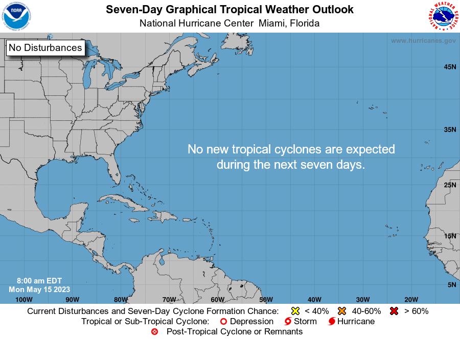
 May 15th is the start of Hurricane Season in the Eastern Pacific, and the beginning of outlooks for us.

The outlooks basically show an area the National Hurricane Center (NHC) is watching for POSSIBLE development. They provide where the area is located, and the zone where it might organize, along with its chances for doing just that. This year the outlook goes out to 7 days, up from 5 on 2022.


Here are the names for 2023, and how they are pronounced


This is what NHC is saying on this 1st Day of the Tropical Outlook issuance

The Tropical Weather Outlook is issued from May 15 through 
November 30 each year.  The issuance times of this product are 2 
AM, 8 AM, 2 PM, and 8 PM EDT.  After the change to standard time 
in November, the issuance times are 1 AM, 7 AM, 1 PM, and 7 PM EST. 

A Special Tropical Weather Outlook will be issued to provide 
updates, as necessary, in between the regularly scheduled issuances 
of the Tropical Weather Outlook.  Special Tropical Weather Outlooks 
will be issued under the same WMO and AWIPS headers as the regular 
Tropical Weather Outlooks.
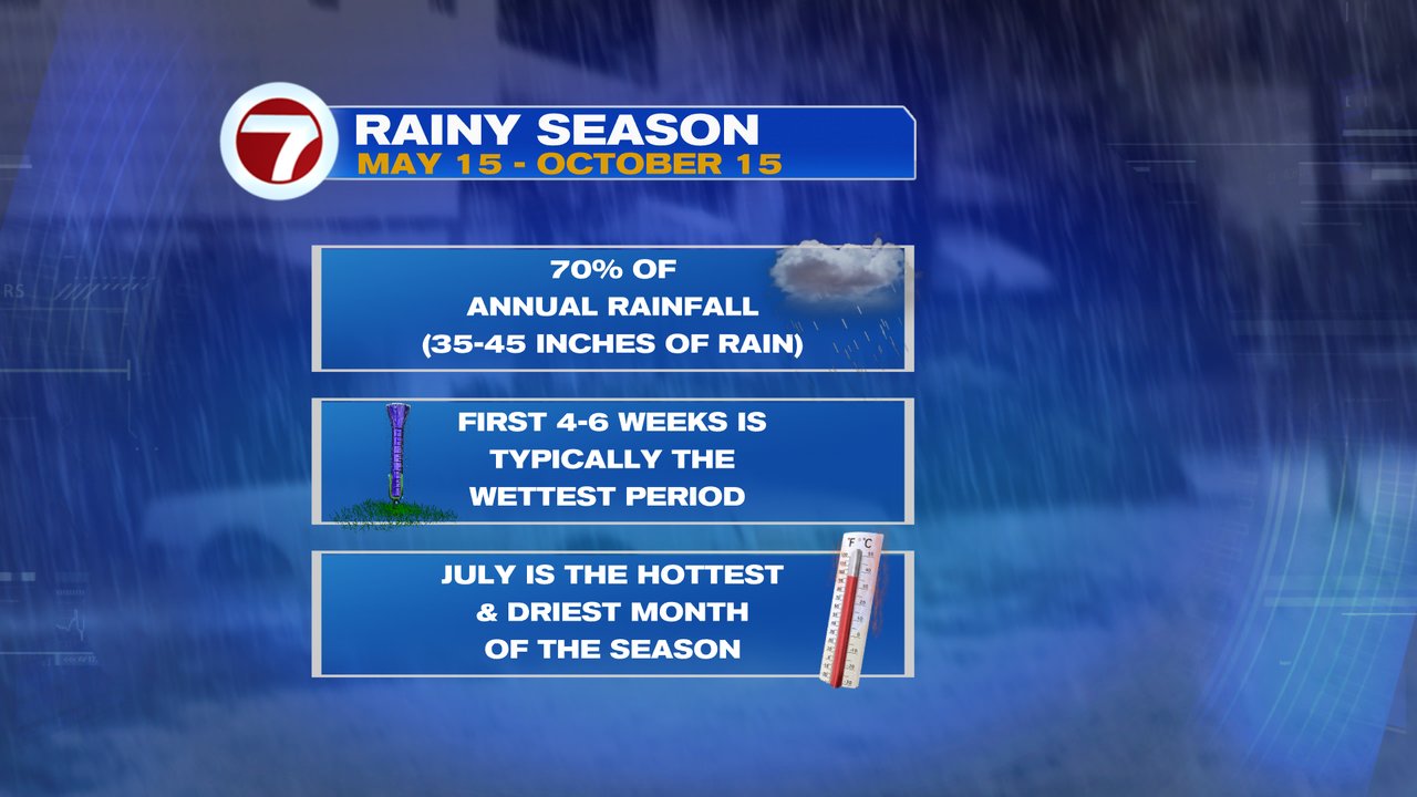
RAINY SEASON
It kicked off Monday and runs thru Mid October. 

Sunday, April 16, 2023

Storms to Return

It's not what anyone wants to see, but after a one in one thousand year rain event last week, more downpours are in store.


Early Sunday evening, activity ahead of a front was already causing massive downpours across parts of Palm Beach and Broward Counties 
There is another blob of clouds and rain across the Eastern Gulf of Mexico which is the leading edge of a cold front that is forecast to arrive by Monday.

Strong Storms


This maps originates from NOAA & NWS. It's an explanation of what is happening in the atmosphere.  Notice a light blue line near Tampa, that is an outflow boundary, or wind and moisture pushed to the ground and out by earlier storms. 

This will continue to cause heavy downpours across the Lake Okeechobee region. Some of that activity is already invading Broward. As of 4 pm, there was only a 20% chance for any storm watch being issued.  That may change for Monday.


Monday's Outlook


For Monday, the front will enter South Florida but NOT clear the area. This will keep plenty of moisture over us an could lead to more heavy rain. This scenario could be the set-up for a very soggy day. There is a marginal risk for excessive rainfall. Some storms may be strong.

Please remain vigilant. With plenty of saturated ground, any additional rain will lead to quick street flooding. With standing water, you may not see where the roadway ends and a canal begins.

Stay with the entire 7Weather team, on-air and on line for the latest.

We'll keep watching.


Soggy Days Ahead

No one wants to hear about the possibility of heavy rainfall across South Florida, specially when our area deals with flooded streets and ho...