Sunday, July 13, 2025

Soggy Days Ahead

No one wants to hear about the possibility of heavy rainfall across South Florida, specially when our area deals with flooded streets and homes so often. Unfortunately, there is a threat for heavy downpours starting Sunday evening and sticking around through Tuesday.


SATELLITE LOOP


You can blame it in part, to this area of clouds and rain just off the SE Coast.  It is forecast to cross the state and emerge over the Gulf waters in the days ahead, pushing moisture in our direction. The National Hurricane Center (NHC), is also looking at this feature for possible organization.


WHERE MAY IT DEVELOP?


NHC THINKING
Environmental conditions could support some gradual development of this system during the middle to late part of this week while it moves westward over the northeastern and north-central portions of the Gulf.  


Regardless of development, heavy rainfall could produce localized flash flooding over portions of Florida and the north-central Gulf coast through the mid to late portion of this week. Presently it has a low chance for organization somewhere inside yellow area.

* Formation chance through 48 hours...low...near 0 percent.
* Formation chance through 7 days...low...20 percent.

WHAT NEXT?
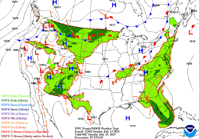

Even without tropical genesis, as the low moves westward, it could keep the state under high probabilities for rainfall thru Tuesday, and maybe even longer.

SOUTH FLORIDA RAIN
This low-to-be in the Atlantic, along with high pressure over the Gulf Waters, will conspire to keep our atmosphere unsettled which may lead to big bouts of rainfall.

NWSMiami suggests:
While there is a risk for a couple of marginally severe storms on
Sunday and Monday, the primary threat for this setup looks to be
periods of steady and heavy rainfall given an overall lack of
significant wind flow in the atmospheric column. 
  • This could lead to stagnant showers and storms as well as training convection, plus chances for cold pools and associated outflow boundaries tospark additional showers and storms over the same areas. 
  • Latest HREF LPMM pinpoints 3-5" or so over the interior sections of South Florida and 2-4" over portions of the east coast metro for Sunday. 
  • If these amounts occur in a short duration of time, localized flooding will be possible. 
  • With this in mind, the Weather Prediction Center (WPC) still maintains a marginal risk (level 1 of 4 and a general 5% chance of rainfall exceeding FFG) for excessive rainfall for the eastern half of the CWA. 
  • On Monday with the disturbance arriving and PWATs rising above the 90th percentile, WPC has a slight risk (level 2 of 4 and a general 15% chance of rainfall exceeding FFG) across all of South Florida.
The above data suggests possible pockets of heavy rain sitting over an area for prolonged periods of time.


BOTTOM LINE
As far as a Tropical Threat for South Florida at this time, the Worry Meter remains low. The potential for heavy rain however, is very high. 
Please stay tuned to WSVN, on-air & on-line for the latest.

Friday, July 4, 2025

Possible Tropical Activity near Florida

The National Hurricane Center (NHC) is monitoring a spin just off the NE Florida coast for possible development.


The actual spin, now area of low pressure, is roughy 100 miles East of Jacksonville, running alongside a decaying front. 

It has been deemed Invest 92L. Invest for an area NHC would like to INVESTigate further, 92 is a tracking number, and "L" stands for the Atlantic basin.

CHANCES FOR DEVELOPMENT


As of Friday morning, atmospheric conditions may support development of a depression late in the day or this weekend... that is, if the center spin can stay over water.  
  • There's a 60% chance for organization between now and the next 7 days. 
  • If it moves inland , then formation chances will drop.
  • A Recon mission is scheduled for later in the day to get a better handle on this system.

WHERE MAY IT GO?


Early model runs are not in agreement. While most show a system along the East Coast on a northward track, others keep it hovering over the SE. Heavy rain potential will be present.

SOUTH FL IMPACTS?


Even if Invest 92L does not turn tropical, the counterclockwise circulation will keep drawing moisture from the Gulf Waters leaving us rather soggy thru the weekend.

Per @NWSMiami
"Expect continuing 
rounds of showers and thunderstorms, with global models depicting 
widespread rain across SoFlo. High-res/CAMs keep rainfall totals in 
the 2-3" range through the weekend. Periods of heavy rain, 
especially with training of cells or terrain anchoring, may 
result in localized urban flooding. LPMM estimates show possible 
isolated accumulation values of up to 5 inches with the heaviest 
or long- lasting downpours. A few overnight showers or isolated 
thunderstorms can't be ruled out." 

The entire 7Weather team will keep you updated on this feature.  Regardless of the rain, we hope you have a safe and dry, 4th of July.

Tuesday, July 1, 2025

4th of July may brew Tropical Activity

The National Hurricane Center (NHC), is monitoring parts of Florida for possible tropical development over the next 7 days.


They suggest we could see an area of low pressure popping up somewhere inside the yellow area. They're giving that possibility a 40% chance of happening, up from 20% Monday.

A weak front will enter Northern Florida by the end of the week, and stall over the region. This usually allows for some spin-ups to happen in the atmosphere. These spins can then turn tropical.

MODELS


🔴 The ECMWF has an area of low pressure emerging near Florida's Big Bend on the fourth. The outlook suggests moisture swinging toward South Florida and allowing downpours to develop.


🔴 THE GFS also places a low near the same area, and here too calling for rain spreading into south Florida.

So far models are not providing any real tangible tracks for whatever may develop, if anything.

LONG RANGE


Beyond the 7 day outlook, NOAA's forecast keeps us on the quiet side of things thru the middle of the month.

CLIMATOLOGY


History shows us that most systems developing in July, tend to do so in the highlighted areas, with the green zone being the most active.

Since a low could develop over a favored site, we'll keep watching for additional observations and analyses to help us in determining what the forecast may be. For the moment, it appears as only summer rain for the Holiday weekend.

The worry meter remains low for the NW Bahamas, South Florida, and Cuba.

Monday, June 30, 2025

First Florida Tropical Concern for 2025?

The National Hurricane Center (NHC), is eyeing the possibility of some sort of tropical development possibly by the upcoming weekend.

WHERE MAY A SYSTEM DEVELOP?


NHC suggests that over the next 7 days, low pressure may develop inside the yellow area. They are giving this possibility, a low 20% probability of actually forming.

WHY?


This is a forecast map valid on Saturday July 5th. It shows a front moving into north Florida and stalling. 

When this happens, it usually has an area of low pressure developing in the Gulf Waters. 

If that does take place, then there may be a chance for some growth of the low.

SOUTH FLORIDA IMPACTS?

Uncertainty in the long term forecast stems from the possibility of a disturbance developing sometime later this week. Some of the deterministic guidance hints at an area of low pressure potentially forming somewhere along the stalled frontal boundary (could be over the Gulf waters, or over the Panhandle, or even over the Gulf Stream waters). 

However, the lack of model consensus or a consistent trend continues to complicate the forecast. If a system does develop, it could potentially help enhance the aforementioned chances for showers and thunderstorms across the region, and elevate the potential for severe and flooding impacts.

This scenario will need to be monitored closely in the coming days. COURTESY NWSMiami

RAIN CHANCES


Over the next 7 days, typical rain probabilities for South Florida range between 50% & 60%. Models suggest this is where we will be thru Friday. Long range into next weekend, keeps the chances on the low end of normal. 

We will have to monitor that as it may change depending on where the low actually develops, if at all.

NO tropical concerns for SE Florida, the Bahamas & Cuba at this moment. The worry meter is low.

If there is a change in the models, the entire 7Weather staff will keep you updated. This is a good reminder that we are hurricane season and we should be prepared in case Mother Nature spins anything our way.


Thursday, May 22, 2025

Official NOAA 2025 Seasonal Forecast

NOAA'S 2025 Hurricane Season Forecast

The National Oceanic & Atmospheric Administration (NOAA) made public their projections on Thursday, as to how active this coming season may be.

They're calling for:


  • 13 to 19 Named systems, out of which-
  • 6 to 10, could turn into hurricanes, and out of this number -
  • 3 to 5 may be stronger than a category 3

What are the factors for this? El Niño-Southern Oscillation (ENSO), sea surface temperatures (SST), and atmospheric conditions. 


Warmer water temperatures. Tropical systems need 80 degrees of water temps to develop. The models suggest higher ocean temps this season.

Strong Upper winds known as shear, will NOT be that plentiful. These winds can keep storms from developing or growing stronger

El Niño, which is an above average warming of the Pacific Ocean and helps keep the atmosphere hostile to hurricanes, will NOT be present

Additional moisture out of Africa could provide another ingredient for systems to form

As always follow myself, and the entire weather team On-Air and on-line for the latest happenings in the Tropics.


Thursday, October 10, 2024

Next Tropical System

Could there be another system developing?  Yes. Could there be a tax hike sometime? Yes 
Will someone win the Lotto? Yes

But we don't know when.

Lets get over Milton before we worry about something, maybe, somewhere developing in the Tropics.

Many social media folks are spewing information with a kernel of truth and blow it out of proportion.

I am being asked constantly about Nadine, where is it? Is it coming. The answers are NO, there is no Nadine (there could be), and NO, we don't know where it will go if indeed it is born.  

So lets take a look at the OFFICIAL nuggets of information available.

This morning The National Hurricane Center issued its forecast for the possibility of another system brewing.

7 Day Odds


  • The map shows the two current systems in the Tropics; Milton finally leaving Florida, Leslie only a worry for the shipping lanes, and a Tropical Wave out of Africa with a 20% chance for becoming a named system, somewhere in the yellow area over a period of 7 days.
  • Maybe something could organize there in a week or so

Now lets look at what many folks are browsing  on-line.  


The map above looks at the possibility of something organizing two weeks in advance.  

  • The top panel shows a red dashed area indicating a 20% chance for development somewhere in the Caribbean Sea.
  • The bottom panel keeps the probabilities the same entering the third week.

Think of how much uncertainty there was over the last few days with Milton. Where was it located? How strong was it? Where will it make landfall? And that was just the last 48 hours. 

Here we are looking ahead almost a month away? Lets take a deep breath and keep the stress level down.
Allow the folks impacted by Milton and Helene the opportunity to put their lives together again.

If Mother Nature does spin up another storm, then I'll be the first to let you know.  

For the moment, all you are seeing are extremely long-range odds. 

As always thank you for following me , and stay safe.

Wednesday, October 9, 2024

D-Day for Milton

Hurricane Milton is set to make landfall late tonight or early Thursday morning as a major system

Satellite Imagery


From the National Hurricane Center
An area of heavy rain is starting to spread across
portions of southwestern and west-central Florida out ahead of Milton.

Weather conditions will steadily deteriorate across
portions of the Florida Gulf Coast throughout the day.

Damaging winds, life-threatening storm surge, and heavy rainfall will extend well outside the forecast cone.

There is high confidence that Milton will remain a very dangerous hurricane when it reaches Florida, and maintain hurricane status as it moves across the state.

Headlines from NWS
Hurricane Milton just SW of Florida is forecast to remain an extremely dangerous major hurricane when it approaches the Gulf Coast late Wednesday

Dangerous, life-threatening storm surge is expected along portions of the SW Florida coast from Wednesday afternoon through Thursday morning

Damaging tropical storm force winds are also expected beginning Wednesday afternoon in SW Florida and spreading east across the peninsula through Thursday

Several tornadoes will be possible tonight through Thursday morning


Impacts
Miami-Dade & Broward
  • Most of the heavy rain is now forecast to wrap around Milton and move north.  
  • The FLOOD WATCH has bee canceled for your area 
  • Tropical storm force winds will still be possible especially with any rain band that moves over our area 
  • Tornadoes: We had tornado warnings overnight and may still see a few twisters through Thursday morning.

For the Keys:
  • Sustained winds of 25 to 30 mph with frequent gusts around 40 mph from later today through tonight and into Thursday morning. 
  • Key West International Airport reported a wind gust of 37 mph. 
  • Storm surge saltwater flooding of 1 to 3 feet above ground level will be possible on the Gulf and Bayside of the Florida Keys from this afternoon through Thursday morning, and possibly into Thursday evening on the Bayside of the Upper Keys 
  • Atlantic facing shorelines will continue to experience crashing waves and over-wash through today and into tonight, causing saltwater flooding in the adjacent neighborhoods. 
  • A Coastal Flood Warning remains in effect for all of the Florida Keys. 
  • The potential for isolated tornadoes will continue across the Keys today and tonight.

Bahamas:
  • Tropical storm conditions are expected in portions of the northwestern Bahamas on Thursday 
  • Grand Bahama Island, the Abacos, and Bimini remain under a Tropical Storm Warning 
  • This means you could see winds over 39 mph when/if a rain band moves over you 
  • Seas will get rough specially once the system moves into the Atlantic
Stay safe


Tuesday, October 8, 2024

Tuesday Milton SE FL Impacts

Milton loses a bit of it's fury but remains a dangerous system. Per the National Hurricane Center, "Milton has the potential to be one of the most destructive hurricanes on record for west-central Florida".

Satellite Loop


Big changes took place over night. The clear-eye from yesterday is now obscured by clouds. 
The system went through an eye wall replacement cycle . This causes the wind speeds to fluctuate.  Intensity will vary until it moves ashore. 

Presently the strongest winds extend out from the center 30 miles with tropical-storm-force winds fanning outward up to 105 miles.

Headlines 
  • Milton has taken a small jog NE 
  • Later today it should move more in that direction and by Wednesday, it's forecast to move a bit faster. 
  • A front being pushed south, will drag Milton to Florida. This should take the center to west-central Florida by tomorrow night.  
Strong upper winds known as shear, will cause some more weakening but models suggest Milton will remain an extremely dangerous hurricane when it reaches the state. 

More recon missions will be underway

SE Florida Impacts


  • NEW - Tropical Storm Warning now in place for Broward & Miami Dade Counties
  • This means that by Wednesday, 39+ mph are EXPECTED 
  • These gusty winds will come and go. A rain band moves in with the 39+ mph winds. Once the band moves out, it's all quiet until the next one arrives. 
  • Milton remains a compact hurricane 
  • The wind field is forecast to grow in size as it approaches Florida and should double in size by the time it makes landfall.  
  • Damaging winds and heavy rainfall will extend well outside the forecast cone. 
  • Mainland South Florida may get 2 - 4+ additional inches of rain with some spots up to 8"
  • The downpours will be intermittent. As the rain bands move over you'll get the wind and rain, then quiet until the next band
  • Winds will increase across South Florida tomorrow with the strongest by nighttime 
  • Tropical Storm Warning also in for the Keys 
  • Milton`s outer bands will push rain in by Wednesday into the Keys, with forecast totals between 2" - 4", with some locations getting up to 7" 
  • The outer bands could also spin up some tornadoes
  • High water is possible up to 3'


For the NW Bahamas
You may get an occasional gust with some rough seas and the potential is there for some heavy rain. Once the system moves across into the Atlantic by Thursday, your winds could pick up as well with the seas getting rough.

Shutters
The ultimate decision is yours as you know your property best. I suggest to put them up when a hurricane watch is issued.

Mobile homes
It is never recommended to ride any tropical system during a storm. Tornadoes can cause damages, and strong gusts may impact the home. It's better er on the side of caution. 
Please stay safe


Monday, October 7, 2024

Monday 8 am Milton Headlines

Dangerous Milton on way to Florida
Now a major hurricane with category 5 winds
Satellite Loop


The latest imagery shows that "buzz saw" look to the system. An eye has emerged and it is firing on all cylinders.


 Headlines
  • Miami-Dade, Broward & the Keys are out of the cone. Impacts will be felt far outside of it
  • The center has nudged a little southward over the past several hours
  • Models suggest the approaching front that should steer Milton toward Florida should start its approach within the next 48 hours. This will force Milton to move east-southeastward to eastward for the next 36 h +/-
  • Then it should start a turn toward the northeast at a faster forward speed. 
  • Models are in good agreement for a Florida impact 
  • Thankfully it appears most models are in agreement that SE FLorida and the Keys will avoid a direct strike.

South Florida Watches & Warnings


All the areas highlighted in yellow are under a hurricane watch. This means hurricane force winds are possible over the area in 48 hours. This will probably be upgraded to a warning by tomorrow.

Areas in the light blue represent a tropical storm watch. This means tropical storm winds of 39+ mph are possible. Miami-Dade & Broward have no advisories. This may change as the system nears the west coast.

Impacts:


This graphic from the National Weather Service gives a preliminary overview of possible impacts. 


SE Florida will get some gusty winds from time to time as rain bands move through the area.
Notice the highlights under Wind and Flooding rains. They will impact all the cities of Miami-Dade & Broward Counties.


Even tropical storm winds can cause damages.


Impacts for the Keys

  • Winds start increasing throughout the area Tuesday night, peaking sometime on Wednesday/Wednesday evening, before diminishing slowly heading into Thursday.
  • Coastal flooding, especially on the Bayside/Gulfside of the Island Chain,
  • High potential for sustained tropical storm force winds, thundery squalls with localized wind gusts of 55 to 65 mph Tuesday night through Wednesday
  • Flooding rainfall with total amounts through Wednesday night most likely in the 5 to 10 inch range with isolated locations seeing as much as 15 inches. 
  • A significant portion of the rainfall will be well in advance of Milton`s closest approach.

Hoping for the best


Sunday, October 6, 2024

Milton 11 pm InfoHurricane Milton

Hurricane Milton continues to intensify.


  • It looks very healthy on satellite imagery 
  • Its traveling over very warm waters which will provide the fuel to grow stronger 
  • Nothing in its atmospheric path presently to weaken it
  • Milton is forecast to be a major hurricane when it reaches the west coast of Florida by midweek. 
  • Please do not focus on the details of the forecast as there remains significant uncertainty in the eventual track and intensity of Milton.

Per NHC:
  • Too soon to specify the exact magnitude and location of the greatest impacts 
  • There is an increasing risk of life-threatening storm surge and damaging winds for portions of the west coast of Florida beginning early Wednesday
  • Storm Surge and Hurricane Watches will likely be issued early Monday
What to look for:


There is a front (Blue line with triangles) moving South. By Wednesday it should be across Northern Florida. If it moves too fast, it will push the system farther south. If too slow, Milton will jog northward. As of this update it seems that Milton should directly impact the west coast. This may change so please stay informed.

SE Florida will still feel impacts:

Chances for Tropical Storm Winds (39+ mph)
Ft. Lauderdale 44 %
Miami 23%
Slightly stronger west of I-95

Marathon 36%
Key West 38%

Chances for Hurricane Force Winds (Over 74 mph)
Ft. Lauderdale 5 %
Miami 2%
Slightly stronger west of I-95

Marathon 3%
Key West 4%
Rain 
  • Localized amounts of up to 6+ inches possible. A Flood
  • Watch is in effect beginning late Sunday morning
  • It is important to note that the next round of rain is not directly associated with Tropical Storm Milton. 
  • Any rain from Milton will happen later in the work week.
For the Keys:
Areas of heavy rainfall will impact portions of Florida Monday well ahead of Milton, with heavy rainfall more directly related to the system expected later on Tuesday through Wednesday night. 

This rainfall brings the risk of considerable flash, street flooding 

We can also expect storm surge to be significant to some degree, but it is still difficult to estimate the exact surge heights. 

Even without the specific details, we do know that we have a few days of wet and messy weather to get through together.

Shutters:
If and when a hurricane WATCH is issued, that would be the time to put them up.

Please keep in mind that the atmosphere is ever changing and there are many factors at play. Stay informed and stay safe.


5 pm Hurricane Milton Update
An agonizing two days await us


Local Forecast Cone


  • The close up cone suggests the southern extent of the forecast track has nudged northward.
  • Please don't read too much into this. It gives us an idea of where the eye or center of the storm may be. Mother nature does not recognize man-made boundaries on a map. The atmosphere is ever changing and so will the cone placement and intensity Milton is getting stronger and will continue to get stronger. 
  • Winds are now up to 85 mph on its way to 145 mph in 48 hours. That's a major cat 4 out 5 levels. 
  • After that, it is forecast to weaken a bit as it nears Florida, but once this happens, models suggest Milton will grow in size. This means many more areas may feel its wrath.
  • As we learned from Helene, many areas outside the cone will be impacted in one way or another.

The cone and intensity will fluctuate until it finally makes landfall so please keep monitoring.

Now for our possible impacts:

Miami Dade & Broward All Cities:
Tropical Storm Force Winds (39 mph and above)
Miami 26% 
Ft. Lauderdale 49%
Areas West of I-95 will see higher chances
Marathon 42%
Key West  48%

Hurricane Force winds (Over 74 mph)
Miami  2%
Ft. Lauderdale 6%
Marathon 4%
Key West 6%
Areas West of I-95 will see higher chances

Rain
  • This will be a major player with 4 to 8 inches possible over saturated ground. 
  • A Flood Watch is in place for South Florida. This means that any additional rainfall may lead to standing water over low lying areas.

When?
There is increasing confidence that a powerful hurricane with life- threatening hazards 
will be affecting portions of the Florida west coast around the middle of this week.

Shutters?
I recommend if and when a Hurricane Watch is issued, that would be the time to put them up. But you know your property best.

Please, this a huge and dangerous, possibly catastrophic hurricane in development. Impacts will be felt far away from wherever it makes landfall. Best to be prepared.

Hope for the best for all across Florida.

Milton Info

Milton is on its way to becoming a major hurricane as it aims for Florida.


From NWS Miami:
  • Tropical Storm Milton over the southwestern Gulf of Mexico is forecast to quickly intensify as it moves east and northeast, and be at or near major hurricane strength when it reaches the west coast of the Florida peninsula mid-week
  • Hurricane or tropical storm watches could be issued as early as late today for portions of Florida
  • Heavy rainfall leading to possible flooding is expected across South Florida through much of this week. A Flood Watch is in effect for the entire area through Thursday morning
  • Increasing risk of dangerous storm surge for portions of the Florida Gulf coast, and damaging wind impacts for portions of South Florida from Milton. 

Here are your headlines:
  • The track may shift northward or southward. Why? A front heading south will dictate Milton's future path. If the front moves fast, then Milton gets nudged farther south. If it slows down... then it will jog northward. 
  • Keep monitoring as the atmosphere is in constant flux. 
  • This is why model runs come out many times a day. 
  • NHC updates the forecast track a minimum of 4 times a day.

If nothing were to change with this system, what can we expect?

Keys: 
  • All guidance points to south to southwesterly breezes in the Keys peaking near tropical storm force (39 mph w stronger gusts). 
  • There will likely be a heightened risk of coastal flooding and fast moving squalls. 
  • It is a bit too early to determine if watches or warnings will be required for the Keys. 

Miami Dade & Broward: ALL CITIES

  • Heavy rainfall and flooding is expected across South Florida through this week. 
  • A Flood Watch is in effect for the entire area beginning late Sunday morning to Thursday morning.
  • Increasing risk of dangerous storm surge and wind impacts for portions of the Florida peninsula
  • It is too early to provide specifics on potential impact locations, but the general time frame of storm impacts in South Florida would be late Tuesday through Wednesday.
  • All potential impacts are in play at this time with Milton (strong wind, significant storm surge, flooding rainfall, tornadoes). 

As of this moment, here are your chances of seeing tropical storm force winds:
  • Miami 26%
  • Ft. Lauderdale 46%
  • All cities west of I-95 could see higher chances

Chances for hurricane force winds (74 mph and above)
  • Miami 2%
  • Ft. Lauderdale 6%
  • All Cities west of I-95  - 5%

Rainfall will be wide spread with anywhere between 6 - 8". This will lead to flooding issues with already saturated grounds.

Please keep monitoring. Many things can & will change with this system which promises to grow stronger. 
 
Questions about shutters:
I recommend when and if Hurricane WATCHES go up for your area, to put them up. You know your property best and how long it may take to put them up.

Stay safe everyone

Saturday, October 5, 2024

Milton in the Makings

The National Hurricane Center (NHC), is issuing advisories on Tropical Storm Milton in the Western Gulf of Mexico. 

Satellite View


The loop has the images transitioning from nighttime into daytime. It shows us a nice cluster of clouds starting to take shape in the Western Gulf of Mexico.

The Latest on TD 14

Its forecast to slowly move eastward and continue intensifying. The Florida Keys, Mainland South Florida and the Bahamas should monitor carefully.

Where is it headed?


The latest track has the system becoming a hurricane by Monday. Then nearing South Florida as a cat 2 almost cat 3 by Wednesday morning. 

Intensity forecasts are very difficult and as we have seen lately, tropical system can intensify rather quickly. Please stay informed and check back often on-air and on-line.

Interesting to note - If the system tracks a bit farther north, it will be impacted by an approaching front and could keep it weak. If it slides south, then a stronger storm is possible. 

South Florida Impacts


Rain will be the biggest threat as of this moment. That may change depending on how strong it gets and tracks. The above graphic provides an idea of potential accumulations over a period of 7 days.

A flood watch is already in place for South Florida.

Forecasts show this heavy rain will lead to flooding concerns, even if the system does not develop. It will be a very wet week.

Heaviest of the rain may arrive from Sunday thru Wednesday. 


Please stay on top of the weather over the next few days. This forecast has a lot of uncertainty as there are many factors that could influence its track and strength.


We'll be watching.


Sunday, June 30, 2024

Dangerous Beryl

A record setting hurricane is churning in the Central Atlantic aiming for the Windward Islands and beyond. It has intensified very quickly.


l
Beryl is now a Powerful category 4 hurricane. Extremely strong winds, life-threatening storm surge, and damaging waves are forecast.
  • When Beryl passes over portions of the Windward Islands, the highest risk of a core impact will be in St. Vincent and the Grenadines, and Grenada beginning early Monday morning.  
  • Heavy rainfall and localized flooding are expected across the Windward Islands thru Monday. 

As of Sunday morning, it has now reached major hurricane status. Quick History update per CSU's Philip Klotzback.

Early morning- Beryl reaches Category 3 hurricane with max winds of 115 mph - the first June major hurricane east of the Lesser Antilles on record. 3rd earliest Atlantic major hurricane on record, trailing Alma (6/8/1966) and Audrey (6/27/1957). 


Mid Morning- Beryl attains winds of 120 mph - the second strongest June hurricane on record.  
  • Beryl trails only Hurricane Audrey (1957, 125 mph max winds). 
Early Afternoon- Beryl reaches category 4 intensity with 140 mph winds!
  • This is the earliest calendar year Atlantic Category 4 hurricane on record.  Old Atlantic record for earliest Category 4 hurricane was Hurricane Dennis on July 8, 2005 

Recon Mission
At 11:35 Sunday morning -NOAA and Air Force Reserve hurricane hunter aircraft data indicated that Beryl had strengthened to an extremely dangerous category 4 hurricane. The maximum sustained winds are estimated to be 130 mph (215 km/h) with stronger gusts.

Forecast Cone


The NHC track forecast has been nudged to the south of the previous run.
  • Beryl is expected to be a very dangerous category 4 hurricane when it moves through Windward Islands.  
  • Strong Upper winds (Shear) should gradually increase when Beryl moves across the Caribbean Sea. It may weaken thereafter BUT  it is expected to remain a significant hurricane through the next 5 days. 

Where to find the strongest winds


This forecast suggests the core of Beryl tracking across the Windward Islands Monday morning and then traveling over the
Caribbean Sea during the following days.  The purple swath is where those winds, 75 mph to Cat 3, (possibly 4 by then) will be registered. 


Areas along the Windward Islands may get up to a foot of rain, while in the Caribbean Sea, the downpours will taper off to 4 to 8 inches.

Two More Areas to Watch


Aside from Beryl, there is another area marked by the red "X", which has a 70% chance for developing over the exact same area Beryl currently resides.

Then in the Bay of Campeche in the Gulf of Mexico,  a low has a 50% chance for growth. Even without development, it's forecast to drop plenty of rain there.

We'll be watching

Friday, June 28, 2024

Tropical Trio

Three Tropical Areas to watch as we head into the weekend. We could see the second named storm of the year and the first Tropical Threat for the caribbean.


What to Watch

1) Close to the Yucatan Peninsula, the National Hurricane Center (NHC), is monitoring Invest 94 L. Invest stands for an area NHC would like to INVEST-igate further, 94 is a tracking number and "L", stands for Atlantic Basin.   30% chance for development.
  • This feature continues to generate showers and thunderstorms as it moves WNW at 15 mph. 
  • Recon flight for today is scrubbed. 
  • It should travel over land and into SW Gulf of Mexico for the first part of the weekend. 
2) Invest 95L - Low pressure roughly 1400 miles ESE of the 
Windward Islands is looking better defined.  Chances up to 100% for formation.


  • Showers and thunderstorms are showing signs of organization
  • A depression or tropical storm could form as early as Friday afternoon.  
  • It's moving W at 15 to 20 mph. 
  • Land approach should be late weekend / early part of next week somewhere along the Lesser Antilles, more likely the Windward Islands.
3) A tropical wave a few hundred miles SSW of the Cape Verde Islands is showing some disorganized downpours 
  • Slow development is possible next week as it moves W at 15 to 20 mph.
Invest 94L 
Satellite Loop


Even though chances for development are low at 30% over 7 days, it'll drop plenty of rain over parts of Central America, Cayman Islands, Cuba, & Yucatan. It may get a better chance for organization by Sunday in the SW Gulf of Mexico.

Invest 95L
Satellite Loop


The first Tropical Threat for the Caribbean. The Lesser Antilles should monitor closely as it could become an organized named system later on Friday or early Saturday.

Wave Action

While the center of the system is forecast to track into the Windward Islands, wave action will be felt as far north as the Leeward Islands by Sunday. As much as 8 foot seas there. Twelve feet along the center path.

Models


Keep in mind that until the system actually organizes, these forecast tracks are a good estimate and not set in stone. The projections are in agreement in the short term to cross over the Lesser Antilles and move into the Caribbean Sea. After that, they fan out which is typical of long range forecasts and also a sign there are too many variables and the models are not handling it well. Better outcomes once we have a good center fix.

Third in Line
Satellite Loop

This wave is the cluster of clouds and rain just off the West Coast of Africa. Should track south of Cape Verde.


Typically we don't see this much activity early in a season, but with plenty of climatic indicators suggesting an active year, we should all be reviewing our storm supplies and readiness.

We'll keep watching
** Some images courtesy of Tropical Tidbits **

Soggy Days Ahead

No one wants to hear about the possibility of heavy rainfall across South Florida, specially when our area deals with flooded streets and ho...